Cartographer
by Sausage Man Good
| Summary | Explore real world maps in S&Box. |
|---|---|
| Description |
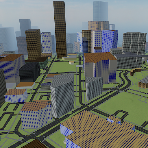
Explore real world maps in S&Box. This is still a pretty rough prototype, but I'd like to think it demonstrates some potential. Features - High resolution (1 meter) terrain data. In the demo it is exaggerated by 2x for effect. - Simple handling of roads. Considers lane count, and whether a road is one-way or a sidewalk. - Very simple handling of buildings. Different materials are applied depending on the building's size. Attributions OpenStreetMap was used to construct buildings, roads, and other features. The copyright for this data is owned by OpenStreetMap contributors. OpenStreetmap is available under the Open Database License. https://www.openstreetmap.org/copyright OpenStreetMap and other map data is transformed using the following program. This library uses several other open source libraries. https://github.com/MDFL64/cartographer-cli Elevation data is provided by the United States Geological Survey. This data is availabe free for charge and without use restrictions. https://www.usgs.gov/3d-elevation-program/ Textures were created using Material Maker. https://www.materialmaker.org/Explore real world maps in S&Box.
This is still a pretty rough prototype, but I'd like to think it demonstrates some potential.
Features
- High resolution (1 meter) terrain data. In the demo it is exaggerated by 2x for effect.
- Simple handling of roads. Considers lane count, and whether a road is one-way or a sidewalk.
- Very simple handling of buildings. Different materials are applied depending on the building's size.
Attributions
OpenStreetMap was used to construct buildings, roads, and other features. The copyright for this data is owned by OpenStreetMap contributors. OpenStreetmap is available under the Open Database License.
https://www.openstreetmap.org/copyright
OpenStreetMap and other map data is transformed using the following program. This library uses several other open source libraries.
https://github.com/MDFL64/cartographer-cli
Elevation data is provided by the United States Geological Survey. This data is availabe free for charge and without use restrictions.
https://www.usgs.gov/3d-elevation-program/
Textures were created using Material Maker.
https://www.materialmaker.org/
|
| Votes | 31 11 15 |
| Error Rate | 0% |
| Reviews |
3 reviews
33.3% Recommended (1)
66.7% Promise (2)
0% Needs Work (0)
|
| Usage |
371 players
740 sessions
260 hours playtime
21 minutes avg session
Totals captured
|
| Data | {} |